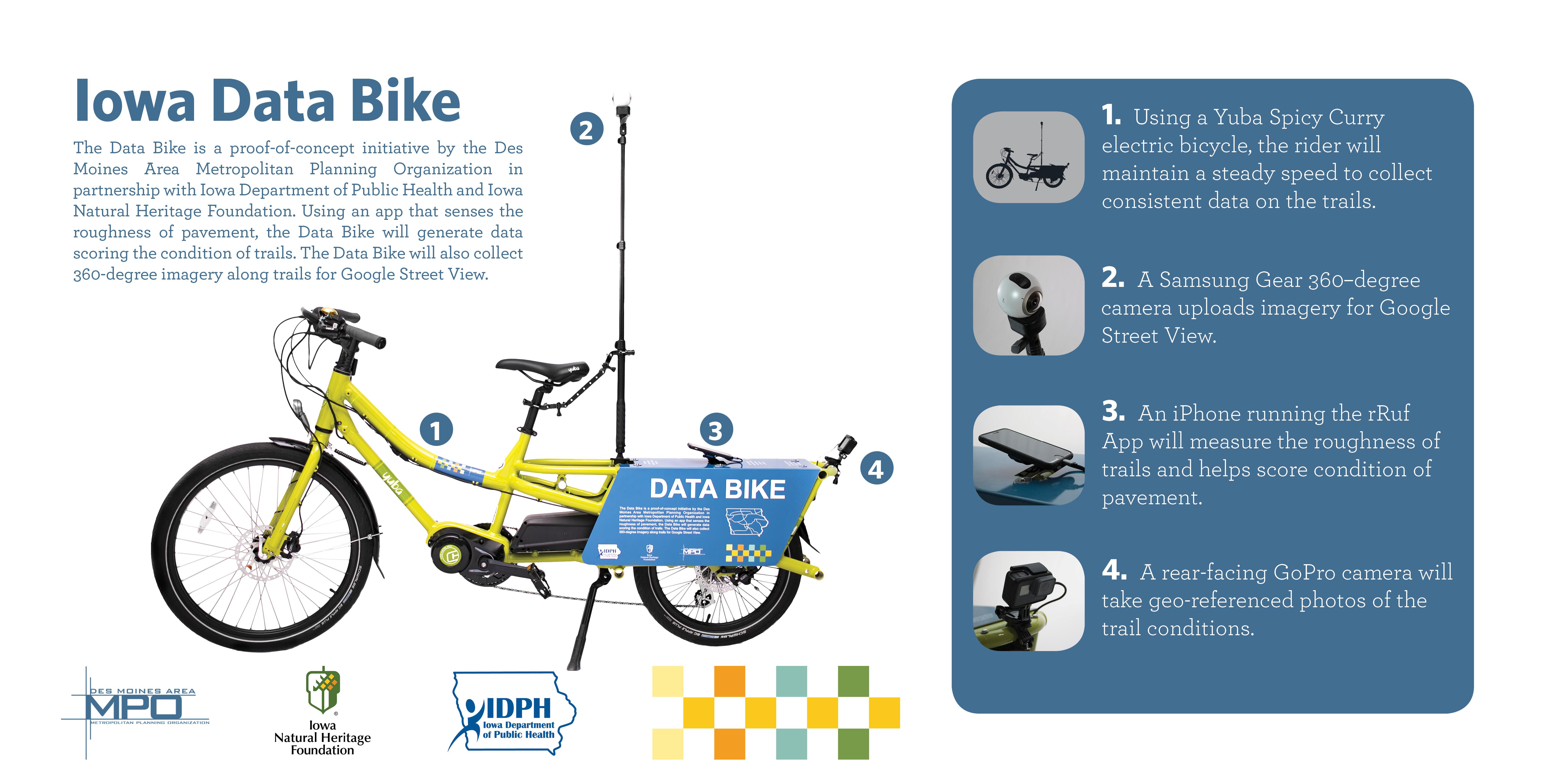
The Iowa Data Bike is an initiative by the Des Moines Area MPO in partnership with the Iowa Department of Public Health and the Iowa Natural Heritage Foundation. Using an app that senses the roughness of pavement, the Data Bike generates a score for the roughness condition of trails. The Data Bike also collects 360-degree imagery along trails for Google Street View.
Background
Central Iowa is home to more than 600 miles of trails connecting urban centers to rural and natural landscapes, providing recreational opportunities for hundreds of thousands of residents and visitors every year. The network of paved trails is starting to mature, and soon local governments will have to shift their spending priorities to focus on the maintenance of existing trails.
Unlike the street network, for which pavement-condition data are regularly collected, there are no pavement-condition data being collected for the paved trail network. Nor is there a means for collecting trail pavement-condition data, as the equipment used on roadways is too large and requires too high of speeds to be used on trails.
Objective
The objective of the Iowa Data Bike project is to develop a bike-based data-collection vehicle, using an electric-assist bicycle, an iPhone, and an iPhone app designed to detect pavement roughness conditions, and then to collect pavement roughness condition data for all paved trails within Central Iowa for the use of the Des Moines Area Metropolitan Planning Organization (MPO) and its and member cities and counties, as well as partner organizations such as the Iowa Natural Heritage Foundation. This data will help inform a long-term maintenance strategy for Central Iowa’s trail network.
In addition to collecting pavement-condition data, the Iowa Data Bike will be used for other valuable purposes to benefit the users of the trail system, as well as the government and nonprofit entities that maintain them. These include collecting Google Street View imagery for all of the trails in the region using a GoPro Max 360 camera as well as collecting geolocated imagery of trail pavement using a GoPro Hero camera.
Central Iowa Trail Roughness Reports
- Central Iowa Trail Roughness Experience Interactive Map
- 2023 Central Iowa Trail Roughness Condition Report
- 2019 Central Iowa Trail Roughness Condition Report
- 2018 Central Iowa Trail Roughness Condition Report
360 Imagery on Google Street View
360 Video on YouTube
Other Data Bike Projects
- COMPASS Data Bike
- Data Bike Pilot Report (2023, 2020)
- FHWA Fostering Multimodal Connectivity Newsletter
- Corridor MPO Data Bike
- MassTrails Data Bike
- National Park Service Trailblazer
- Parks & Trails Council of Minnesota ResearchBike
- TrekView DIY Street View Bike
Iowa Data Bike in Media
- INRCOG Black Hawk County Trail Pavement Condition Data Interactive Map March 2024
- FHWA Fostering Multimodal Connectivity Newsletter Fall 2023
- Iowa State University InTrans En Route Annual Report January 2022 to December 2022
- Globe Gazette “Data Bike provides trail conditions in Mason City, Cerro Gordo” December 20, 2022
- City of Johnston “Trails Data Bike” August 2022
- The Des Moines Register “Warren County officials hope to use state, federal grants to repair Great Western Trail’s ‘failed’ surface” July 14, 2021
- TrekView “Measuring the Condition of Cycle Paths With Only Your Phone” March 12, 2021
- The Daily Nonpareil “Our View: A stitch in time…” September 20, 2019
- Newton Daily News “Data Bike to pinpoint trouble spots on Iowa trails” June 20, 2017
- Toronto Star “How to map a bicycle trail while riding a data bike” June 17, 2017
- Next City “Data Bike to Hit the Trails in Des Moines” June 1, 2017
- Lechner Tudásközpont Iowa Data Bike
- The Des Moines Register “Data Bike pinpoints trouble spots on central Iowa trails” May 20, 2017
ABOUT THE IOWA DATA BIKE PARTNERS